
GRAVELISTHEPITS.COM
This website will provide information about the application of Thelen Sand and Gravel to put in a Sand and Gravel Mine in Randall Township, Kenosha County, Wisconsin per their 2004 application. This proposed sand and gravel mine is 450 acres and is surrounded by residential communities containing dozens of homes and hundreds of people, including numerous small children.
This website will be a community resource to keep everyone informed about developments.
IF YOU ARE DISTRIBUTING ANY OF THESE DOCUMENTS BE SURE TO NOT USE MAILBOXES. THIS IS NOT PERMITTED UNDER USPS REGULATIONS AND IS AGAINST THE LAW.
We also have a discussion forum where you can post your ideas, read community comments and get involved. HERE
Quick "Fact Sheet" on the Thelen Mine HERE
WHITE PAPER ON THE THELEN MINE PROPOSAL HERE
UNDERSTANDING THE STEPS IN THE PROCESS HERE
For some draft Smart Growth Interview Responses click HERE
We are posting names and contact information of elected officials HERE. As we get more of them, we will add to this list.
Basic understanding of LOGIC and ARGUMENT in public debate is HERE. Be more effective in speaking with elected officials and others in the community by framing your concerns and responding to statements based on an understanding of these issues.
The next events to consider are:
Joint Randall Twin Lakes Smart Growth Meeting taking place on Wednesday November 3, 2004 at 7:00 pm. We understood they plan to continue at the Lakewood School for some time until they see what the crowds look like. The agenda will NOT be on the gravel pit at this point, and our position is that we should be "monitoring" these meetings for the time being, but we do want them to get their work done and move the planning forward so it can (hopefully) be adopted in the not too distant future. We understand the Smart Growth meetings take place the 1st and 3rd wednesdays of every month generally.
Spring Grove, Illinois Town Board Meeting taking place on Monday November 8, 2004 at 7:00 pm at the Spring Grove School, Main Street, Spring Grove. This is a continued version of the hearings that took place on October 18, with more citizen comments about the proposal. Just prior to the last meeting Thelen asked for a delay in their application. The Spring Grove board kept the meeting open for the citizen comments however.
URGENT MEETING:
Randall Town Board Meeting: taking place on Thursday November 11, 2004 at 7:30 pm at the Randall Town Hall in Bassett. Randall holds their town board meetings on the 2nd and 4th thursday of each month. As a result of discussion at the meeting of October 28, and a proposal to clarify and extend the moratorium currently in place in Randall regarding big subdivisions to specifically address and deal with gravel mining (which was in nobody's mind when the initial proposal was adopted or it would have been addressed), the Randall Town Board has agreed to put this question on the agenda for the November 11 meeting and put it before the Planning Commission and the Town Board, and we would expect that it will be adopted at that time, to carry out the overall intent of the community and the previous position of the Board to not undertake irremediable changes prior to the adoption of the Comprehensive Joint Smart Growth plan. We recommend everyone who can make it to come to this meeting as this moratorium can provide us very substantial support in our ongoing opposition to this proposal.
Here are the dates/times for Kenosha County meetings which
are of importance to us in general. We are informed that no formal proposal
has yet been made by the Thelen's to Kenosha County, but when they do, we will
need to address the matter in the following venues::
Board meets 7:30pm on the 1st and 3rd Tuesdays of each month at the Kenosha
County Administrative building in Kenosha.
Land Use Committee meets 7:00pm on the 2nd Wednesday of each month at the Kenosha
County Center on 50.
Board of Adjustments meets 6:00pm on the 1st and 3rd Thursdays of each month
at the Kenosha County Center on 50.
Current Status:
Randall Town Board had a recent meeting at which Thelen presented an informational presentation about their possible plans and it was made clear by the Randall Town Board at that meeting that no formal application has yet been made and they have not made any decisions. However, at least one of the Board members has advised a constituent in the community that planning has been going on for months and that the Board is prepared to approve this application and that Kenosha County Zoning will simply rubber-stamp anything that Randall Board recommends, and there is basically nothing that anyone can do about it. That it is Thelen's land and he can "do whatever he wants with it".
Thelen has made a formal application already on September 13 to the Randall Twin Lakes Smart Growth committee to formally accept the mining purpose of this site and change the Smart Growth plan and the maps relating to it to acknowledge and accept this use of the property.
Currently the property is zoned A-1 Agricultural preserve. In order to be approved, we understand that Thelen must obtain formal approval of the Randall Town Board and the Kenosha County zoning. Inclusion in the Smart Growth plan makes it that much easier for Thelen to accomplish his goals.
The community is upset as this both violates the expressed will of the community about the nature of Randall and its future as set forth in the Smart Growth Surveys sent out last year, as well as creates negative health and property value effects for hundreds of residents of the community and apparently, the Board is willing to do this without so much as a serious weighing of the consequences to others.
At a recent informational presentation made by Thelen to the community at the September 9 Randall Town Board meeting, they indicated they need this mine because their Fox Lake mine is running out of gravel soon, AND they have no other alternatives anywhere that they either have in hand, are attempting to acquire or are researching.
It should be noted that at the same time they were making these statements to the community (it is on the record as the meeting was being recorded by the Village Clerk), they were going in front of the Spring Grove Illinois board for annexation and permitting of a large expansion of their Fox Lake facility. It should be further noted that knowledgeable people have indicated they still have at least 20 years of mining to do at Fox Lake. Clearly, we have to weigh the statements coming out of the Thelen company very carefully and be sure to bring forward any information that sheds light on their real situation.
Over the years various community members have been told by various members of the Thelen company that they had absolutely no intentions of mining this area, and on this basis, development has in fact occurred or houses have been purchased or built over the years.
The Spring Grove Illinois meeting was a packed house of angry Spring Grove residents. Many of these people have real experience with living near a Thelen open pit sand and gravel mine and suffering the dust, noise, traffic, air pollution and health problems associated with it. A number of these individuals testified about the problems they have experienced at the Spring Grove board meeting and some of this information was written up in the local newspaper there.
One of our local residents drove through the Wilmot Road/Highway 173 intersection friday afternoon 9/24 and reported that it was hard to drive, not only because of the truck traffic but because of the dust haze that blanketed the entire area.
At the October 6, 2004 Smart Growth meeting in Twin Lakes, the committee kindly made some time at the beginning of the meeting for us to address the concerns we have about the Smart Growth plan being changed to put mining into the community and the Thelen mine proposal in particular. An overflow crowd of local residents showed up to make their views known about the mine project, to the point where it was not only standing room only, but people were standing out in the hall unable to get in. Thelen was there and was overheard to tell his friends that he would call the police to have the meeting shut down for a violation of the fire code for room capacity. As a result, the presentation being made by your Gravel is the Pits representative was cut short in mid-sentence. We were able however to present an information packet including a white paper and some documentation to the Smart Growth Committee for inclusion in the formal record, with a copy for each of the 12 committee members and the members of the press who were in attendance.
The Smart Growth Committee then agreed to re-schedule the presentation by making a formal agenda for this issue at their next meeting on October 20, and they have agreed to have the meeting at the Lakewood School so that it can accomodate the local community which is taking unprecedented interest and fighting for their homes, their families, their children and their community. This will be your official opportunity to "be heard" on this issue.
Results of first community meeting Saturday 9/25/04: An overflow crowd showed up for the saturday morning meeting. Serious discussion took place and people volunteered to make sure that our entire community is both aware of the situation and the serious concerns that arise, as well as the zoning implications involved. A number of people are going out on Sunday to speak with neighbors who have not yet received the basic informational packet.
During the meeting it was mentioned that people in a neighboring community of Spring Grove Illinois have already been suffering under the health effects of a Thelen sand and gravel mine, and are fighting to prevent further expansion of that mine being sought by Thelen, which would bring the mine right up to the edge of the community there. It was decided at the meeting that we should extend our cooperation and support to our neighbors to the south as they are facing the very same kind of health and community issues that we are.
Results of the second community meeting Saturday October 2, 2004: Once again an overflow crowd shoped up on saturday morning, again on short notice. After discussing the results of the Thelen informational meeting that took place on September 29 (at which time Thelen did not make any presentation to the hundreds of people who showed up, but rather chose to speak "one on one" with people at easels), and where community questions were not responded to when they were inconvenient to the Thelen's in the one on one presentations, and where a number of people came out with different versions of what was going to happen based on what they were told by the different Thelen representatives, we discussed how to continue building momentum for the community awareness project. Several people volunteered to make phone calls, several agreed to continue circulating the petitions (we now have over 400 signatures by the way in just a couple of weeks with just volunteer part time effort), some agreed to make lawn signs and get them delivered and it was agreed that we should focus on attending the various board meetings and ensuring that this issue gets the attention of the various Boards and Committees who have some control over the process, starting with the Smart Growth meeting on October 6, 2004 at Twin Lakes Village Hall. Over 40 people at the meeting indicated they would be at the Smart Growth meeting at that time and they would tell their friends and neighbors as well.
Results of the October 20, 2004 Smart Growth Commission Meeting Gravel Agenda: The community turned out in large numbers for this meeting at the Lakewood School. Several representatives of Gravel is the Pits made formal presentations to the commission, and State Senator Robert Wirch showed up and encouraged the people to hold their elected officials accountable, to stay strong and united and not give up. He shared his experience in Pleasant Prairie about 10 years ago where he was involved with a gravel pit proposal which was also defeated. A number of citizens spoke about their specific concerns, such as water table, air pollution, asthma, quality of life, open space, rural atmosphere, noise, and property values. The Thelen organization had their geologist explain to us why it is that they think we should sacrifice our property values and our health so they can mine the gravel that happens to be next to us. It was pointed out that they should have either done it 30 years ago prior to all the homes coming into the area, or at least made it very clear so that all developers who put up houses would have known and advised home buyers over the years of the future plans. They have now waited too long until there is too much density. The Smart Growth Committee seemed quite receptive to the citizen input and are clearly hearing the concerns. It is now up to us to ensure that all the governmental bodies carry out the will of the residents. Representatives of Spring Grove residents fighting the Thelen proposal in Spring Grove Illinois joined us and pointed out that they are not getting the compliance information or cooperation from Thelen that they have demanded in their board meetings. The people of Spring Grove have been living with a Thelen mine for years and are fighting against expansion there that was NOT included in Thelen's proposal to Spring Grove 8 years ago! The Thelen mine is viewed by our community as a cancer destroying the health and fabric of our community. We the citizens are the immune system of our community fighting to prevent this cancer from destroying our lives, our property values, our health and our community.
Results of the October 23, 2004 community meeting: Over 40 members of the community met to continue organization and determine the next steps in our fight to prevent this mining operation from taking place in this location. Volunteers came forward to carry out a wide variety of activities, and it was decided to incorporate the organization. Officers and directors were elected at the meeting. It was determined that any new officers or directors would be incorporated into the existing Steering Group. Several people volunteered to conduct needed research on several lines of review. It was agreed that we should have someone monitoring all Randall Town Board and Smart Growth committee meetings, and other meetings where applicable, and that any meetings with an agenda that concerns the gravel pit proposal should be heavily attended. People were encouraged to begin documenting concerns, harm and other potential evidentiary facts in writing, and to continue writing letters to the appropriate governing bodies and the local media.
Results of the Randall Town Board Meeting of October 28, 2004: One of the town supervisors attempted to have a resolution put on the agenda but the Town Chairperson refused to do so, on the basis that she felt the resolution would be best dealt with at a meeting at which the full board and the planning commission would both be in session, which would be November 11. The proposed resolution was intended to deal with a "loophole" in the current development moratorium that was not specifically written to exclude gravel mines going in, because at the time, no one even dreamed that such an issue would come up. The moratorium holds off any development plans or zoning changes or conditional uses until the adoption of the Joint Comprehensive Smart Growth Plan, and at the current time only deals with large residential subdivisions specifically. Therefore, the issue will be formally on the agenda for the November 11, 2004 meeting and we encourage as many people as can be there to show up and observe how our representatives work to adopt the expanded moratorium in line with the expressed will of the people and within a framework to prevent things from happening that would otherwise conflict with the Smart Growth plan.
What can be done:
The community should be meeting and discussing how to proceed. Send your comments in opposition in letters to Randall Town Board, Kenosha County Zoning and Planning, and the Twin Lakes / Randall Smart Growth Committee.
We should be monitoring all relevant meetings and applications and participating in those meetings.
IF YOU ARE DISTRIBUTING ANY OF THESE DOCUMENTS BE SURE TO NOT USE MAILBOXES. THIS IS NOT PERMITTED UNDER USPS REGULATIONS AND IS AGAINST THE LAW.
Sign and circulate the petition and return it to us. Find the petition HERE
Information must be circulated to the entire affected community. Letter to Thelen Neighbors is HERE
All requirements of Kenosha County zoning must be insisted on and met in a comprehensive application by Thelen and these issues should be carefully monitored.
We should insist that our elected representatives carry out the will of the citizens and not simply disregard the health and well being and property values and rights of the community. Send your own letters to each of our elected officials, and particularly to the Randall Town Board, Twin Lakes/Randall Smart Growth Committee and the Kenosha County Zoning and Planning Committee. Be sure to mail copies of all letters to Gravel is the Pits, P O Box 2, Wilmot, WI 53192 (or hand them off to one of the steering group) so we can make sure they get into the record!
We are posting names and contact information of elected officials HERE. As we get more of them, we will add to this list.
If you have a specific grievance or issue with the Thelen proposal or their
existing operation in Fox Lake, Illinois (for instance windshield damage from
gravel which we hear frequently), you should contact Thelen Sand and Gravel
in writing, with a copy to Gravel is the Pits. Thelen's address is: Thelen Sand
and Gravel, 28955 W. Route 173, Antioch, IL 60002-9116 PH: (847) 838-8800, FAX:
(847) 395-3452 Attn: Steve Thelen. Be sure to also copy Gravel is the Pits on
any reply you receive.
Matters of Right and Equity:
The argument being made that "this is Thelen's land and he can do whatever he wants with it" is FAULTY. That is why zoning laws exist! The zoning laws are meant to harmonize conflicting uses where they meet each other, and in the cases of certain potential uses, they are prohibited. The entire purpose of zoning and "smart growth planning" is to avoid circumstances where one property owner, in exercising their "rights" can harm many others. Thelen bought this land knowing it was zoned A-1 Agricultural preserve, and he has no right to expect that the zoning and use would be changed. On the other hand, all the other property owners moved here with an expectation about the peace, quiet, and healthful clean environment they were moving into in the community, and have paid property taxes, land values, home values and interest on mortgages based on that expectation. All of these values will be harmed or destroyed by the rezoning and conditional use requested by Thelen and the argument that he can "do whatever he wants" is erroneous and certainly a wilful disregard of the rights and values of the community and the purpose of zoning ordinances.
There are very serious known health consequences of sand and gravel mining, particularly for young children and the elderly. There are many young children in the community and we cannot overlook the harm to these children when reviewing this application. Quick points on the health issues is located HERE
We are not talking about a public service here, or some general community benefit for which it can be said that some citizens have to make sacrifices so the general community can benefit. In fact what we are looking at is a private business that is attempting to enrich its private owners while creating both hazards and financial losses to a local community. Further, we are looking at a direct contradiction of the basic principles of zoning, as can be seen from the Kenosha County zoning ordinances and the draft Smart Growth plan, to ensure that the health, welfare and property values of the citizens are preserved by avoiding conflicting uses in abuting zones. And finally, we are looking at a matter of equity. Thelen has owned the property for over 30 years. They have stood by and watched a community with numerous houses and many children grow up around them. During that time they have told people they intended to keep it Agricultural and had no mining plans. They bought and kept the land as A-1 agricultural preserve for which they got special tax breaks with the understanding they would be leaving it agricultural. The community had the right and expectation that they would be honoring this commitment and as a result, enormous financial investment has been made by the hundreds of families in the surrounding area. One citizen does not have the right under any circumstances to enrich himself by overturning the basic rules of zoning and balance at the expense of hundreds of his neighbors. It does not matter WHERE this occurs. The principles of fair play and equity under the law would deny this attempt; and it is only because of Thelen’s wealth and the influence that comes with it that we are even having this discussion.
The people of this community are law-abiding, hard-working and patriotic. They have made and continue to make required sacrifices for the good of the community and the country. But there is no “good” of the community or the country, and certainly not an over-riding “good” of the community or the country that is involved here. Rather it is simply to benefit one very powerful family at the expense of hundreds of ordinary citizens and their families.
We are also not just talking about a little “inconvenience” here. There are absolutely known and recognized serious air pollution and health issues that arise from sand and gravel mining. No one has the right to harm the health of hundreds of people in this way. That is why the zoning laws specifically recognize that such conflicting uses need to be avoided. We have attached at the bottom of this page the Kenosha County zoning ordinances and conditional use permit issues that specifically address sand and gravel mining. It will be noted that such activity is deemed to be INHERENTLY harmful and therefore should not be sited immediately adjacent to residential communities.
For most if not all of the families of this community, our homes are our single most valuable and important financial investment as well. Much of the value of the homes in this community comes from the peace, quiet and rural character of the surrounding community. No one person has the right to enrich themselves while concurrently harming the land and property values of hundreds of their neighbors. Families who have worked hard all their lives to build up equity in their property, to create an asset for their retirement have the right to protect the value of this asset, and it is a basic principle of fairness and equity under the law (and discussed in the draft Smart Growth plan and the Kenosha County zoning ordinances) that property values should be protected. Preservation of these financial assets means the difference in many cases between a healthy life and enjoyment of the rewards of a lifetime of hard work, and serious hardship.
A number of "for sale" signs have sprung up around the area of the proposed pit, and at least one has already had to reduce the price on the house since the pit proposal has arisen in the last month. (See actual sign in front of house on Highway F across from the proposed mine property:

It should be further noted that Municipalities in Wisconsin are beginning to recognize the inherent hardship on other property owners of having sand and gravel mining adjacent to residents, for instance, Saukville, Wisconsin has a statute prohibiting any sand and gravel mining operation from being approved if there are 30 or more residents within 3/4 mile of the property. Clearly there are far more than 30 residents within this distance in the Thelen proposal. The population density in the area is hundreds! To see a copy of the Saukville Wisconsin Sand and Gravel Mining Ordinance, click HERE
The Wilmot Ski Hills spoke up at the Joint Randall Twin Lakes Board Meeting on October 12, 2004 and reported that the mine will negatively affect their ability to run the ski hill because the dust gets onto the slopes and they have to make a lot more snow to stay ahead of the grit. They already have difficulties from the Thelen Highway 173 pit which spews out enormous amounts of ambient sand and dust (in violation of air polllution control requirements), and they feel it would be a severe hardship to their business and possibly make it impossible to provide a good skiing experience (ever tried to ski on "grit"?)
Someone else at the same meeting pointed out that the proposed conveyor would require 5 electrical substations with all those implications.
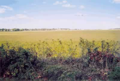
"BEFORE" IMAGE OF PROPOSED SITE FROM HWY. C SOYBEAN FIELD IN FALL:
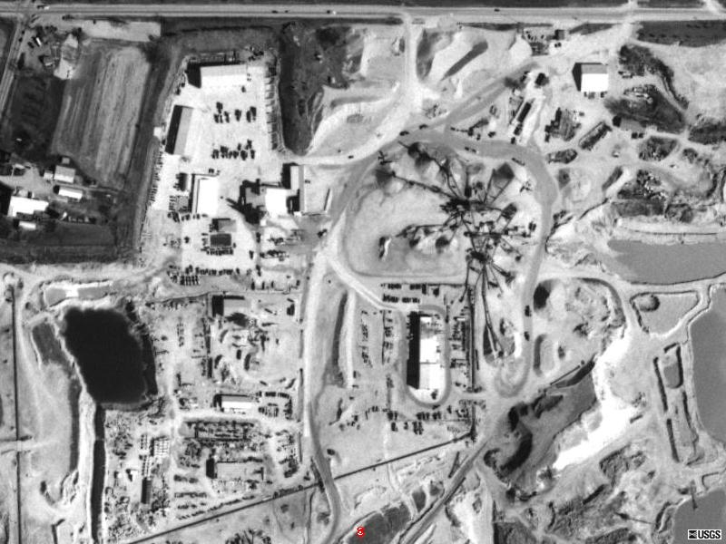
"AFTER" IMAGES OF THELEN FOX LAKE PIT:
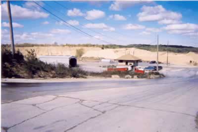
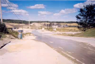
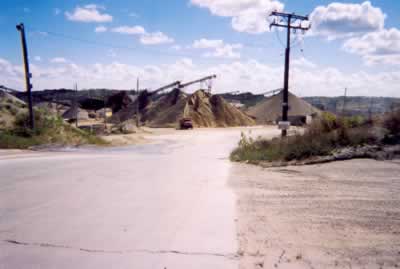
Enjoy the view......
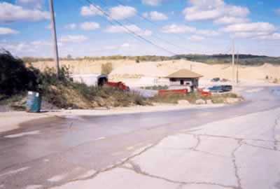
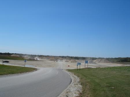
DUST RISING FROM HWY. W PIT (S. OF CK) ON NO WIND DAY:
This was taken on a calm day, but most days we have some breeze or strong winds and then the dust really gets up and spreads everywhere. Even on a calm day you can see dust rising from the work going on in the pit, adding particulate matter to the atmosphere. Kenosha County is a non-compliance area according to the EPA for particulate matter.
Some websites that provide information about the health impacts of sand and gravel mining include:
US EPA Fact Sheet Health and Environmental Effects of Particulate Matter
US EPA Particulate Matter Chief Causes of Concern
US EPA Health and Environmental Impacts of Particulate Matter
American Lung Assn. Particulate Matter Air Pollution Fact Sheet
Sand and Gravel Mining Health Effects
National Institutes of Health Impact on Surrounding Residents
Crystalline Silica Respiratory Health Impacts
Report on Health Impact of Sand & Gravel Mining
http://www.aqmd.gov/rules/proposed/r1157/sr_071604.doc (proposed rules to control the serious health consequences of sand and gravel mining by a California jurisdiction)
Crystalline Silica and its Health Impacts
Information on Air Quality and Particulate Matter Issues in General including Health Effects:
US EPA Letter to Wisconsin State re: Kenosha County Non-Attainment Status for Particulate Matter
Wisconsin DNR Regulations re: air pollution and sand and gravel mines
National Wildlife Federation Article on Particulates and Health Concerns
Health Effects of Particulate Matter Testimony to the Senate by Samet, MD
Particulate Matter: Why Does It Matter?
Environmental Exposure Report Particulate Matter Gulf War
A website about the destruction of a community with a sand and gravel mine is located at:
Destruction of Rural Character of New Mexico town and Health Impacts of Sand & Gravel Mining
Environmental and Health Impacts of Sand & Gravel Mining in New Mexico
Groundwater Drawdown Issues:
Southeastern Wisconsin has the heaviest drawdown of water from its aquifer and the density of the population makes this a critical issue. Below is a University of Wisconsin issues paper on this problem. The use of groundwater for a proposed mining operation, and the potential for contamination of the groundwater makes this a major issue that militates against the granting of a permit for the proposed mine:
Contacts and More Information:
email: info@gravelisthepits.com
mail: Gravel Is the Pits, P O Box 2, Wilmot, WI 53192
telephone: Santosh Krinsky at 262 877 9396
ARC contact: Advocates for Rural Character email: ruralcharacter@charter.net or call Murray Saxon at 262 877 8920
Formal Opposition Documents Outlining Concerns:
Smart Growth Committee Opposition to Thelen Application
Randall Town Board Opposition to Thelen Application
Agreement documenting the formation of the Smart Growth Committee for Twin Lakes and Randall: HERE
Registered to vote? The time is NOW!!! It is crucially important
that let your voting power be heard. The proposed mine is an issue that you
obviously take exception to, why not try and do something about it. Some people
don’t register to vote because they feel voting will change nothing, or
they just don’t have the time.
Well, keep this in mind, your opposition to the mine means much less in the
eyes of the politicians… when they know you are not willing to go out
and vote. By registering now, you can help send the message that you won’t
take it lying down.
Here is an extremely easy way to register:
Just click right here www.justvote.org
Information on the Kenosha County Requirements for Conditional Use: (relevant passages excerpted from the Kenosha County Zoning Ordinances)
According to Kenosha County Zoning Ordinances, Sand and Gravel Mining Operations are in a classification that are considered hazardous, noxious and harmful and thus require extra documentation in order to be considered:
Kenosha County Conditional Use Permit requirements for non-metallic mining:
General Purposes of the zoning ordinances of Kenosha County:
12.01-2 PURPOSE
(a) It is the finding of the Kenosha County Board of Supervisors that the regulation of land uses within Kenosha County serves to promote the general welfare of its citizens, the quality of the environment, and the conservation of its resources.
(b) The purpose of this ordinance is to regulate and encourage the use of land, waters and structures in Kenosha County in a planned and orderly manner so as to promote the public health, safety, morals, prosperity, aesthetics, comfort, convenience and general welfare of the citizens of Kenosha County.
(c) It is recognized by the Kenosha County Board of Supervisors that a Shoreland and Floodplain zoning Ordinance enacted pursuant to Wisconsin Statutes, section 59.971 may be enacted separately from a general comprehensive zoning ordinance enacted pursuant to Wisconsin Statutes, section 59.97 for the reason that compliance by townships with a validly enacted shoreland/floodplain zoning ordinance is mandatory while town compliance with a general comprehensive zoning ordinance is voluntary. Nevertheless, it is the finding of the Kenosha County Board of Supervisors that there are certain advantages to combining the provisions and maps of both ordinances so as to afford the general public a clear and concise presentation and understanding of all zoning regulations which may pertain to a particular parcel of land. Therefore, while this general comprehensive zoning ordinance enacted pursuant to section 59.97 of the Wisconsin Statutes shall be applicable in all towns so adopting it, it shall also serve as a shoreland/floodplain zoning ordinance in all townships irrespective of town approval as mandated by section 59.971 of the Wisconsin Statutes and so as to effect the purposes of section 59.971 and section 144.26 of the Wisconsin Statutes.
12.01-3 INTENT
(a) By the enactment of this ordinance, it is the intent and objective of the Kenosha County Board of supervisors pursuant to the authority cited in section 12.01-1 of this ordinance those areas falling within the jurisdiction of this ordinance to accomplish the following within: 12-2 (4/13/04)
1 Regulate the use of all lands, buildings, structures and waters in the unincorporated areas of Kenosha County so as to determine, establish, regulate and restrict:
a The areas within which agriculture, forestry, industry, trades, business and recreation may be conducted;
b The areas in which residential uses may be regulated or prohibited;
c The areas in and along or in or along natural water courses, channels, streams and creeks in which trades or industries, filling or dumping, erection of structures and location of buildings may be prohibited or restricted.
2 Designate certain areas, uses or purposes which may be subjected to special regulation.
3 Determine, establish, regulate and restrict the location, set back, side yard, height, bulk, number of stories and size of buildings and other structures.
4 Determine, establish, regulate and restrict the location of buildings and structures designed for pecific uses and designation of uses for which buildings and structures may not be used or ltered.
5 Determine, establish, regulate and restrict trailer camps or tourist camps and motels or both and mobile home parks.
6 Regulate population density and distribution.
7 Determine, establish, regulate and restrict the percentage of any parcel which may be occupied, size of yards, courts and other open spaces.
8 Provide healthy surroundings for family life.
9 Provide areas for peace and quiet, open space and privacy.
10 Determine, establish, regulate and restrict the location of roads and schools.
11 Insure adequate highway, utility, health, educational, recreational and other public facilities.
12 Lessen congestion in and promote the safety and efficiency of streets and highways; regulate parking, loading and access for safety and efficiency purposes.
13 Secure safety from fire, explosions, flooding, panic and other dangers.
14 Provide adequate light, air, sanitation and drainage.
15 Establish performance standards so as to guard against air and water pollution, unnecessary contamination, noises, vibrations and odors, and also glare, heat, fire, flooding, radiation, and other hazards and nuisances.
16 Promote the efficient and economical use of public funds.
17 Protect property values and the property tax base.
18 Recognize the needs of agriculture, forestry, industry, business and recreation and future growth.
19 Further the appropriate use of land and encourage uses of land and other natural resources which are in accordance with their character and adaptability.
20 Prevent and control soil erosion, sedimentation and water pollution of the surface and subsurface waters.
21 Further the maintenance of safe and healthful water conditions.
22 Prevent flood damage to persons and property and minimize expenditures for flood relief and flood control projects. 12-3 (4/13/04)
23 Preserve shore growth and cover and promote the natural beauty of the shoreland and floodplain areas.
24 Protect fish and animal life including the spawning, resting, nesting, nursing
and feeding areas.
25 Implement those municipal, county, watershed, and regional comprehensive
plans or components of such plans applicable to and adopted by Kenosha County.
26 Obtain the wise use, conservation, development and protection of the county's water, soil, wetlands, woodlands, wildlife and other natural resources and attain a balance between land uses and the ability of the natural resource space to support and sustain such uses.
27 Preserve natural growth and cover; promote, stabilize and protect the natural beauty and amenities of landscape and man-made developments within the county and encourage the future aesthetic development of the county.
28 Preserve historical sites.
29 Preserve neighborhoods and eliminate blight.
C. CONDITIONAL USES
12.29-1 PURPOSE
A conditional use, as used in this ordinance, is designed to be a flexibility
device designed to cope with situations where a particular use, although not
inherently inconsistent with the use classification of a particular district,
could create special problems and hazards if allowed to develop and locate as
a matter of right in a particular district and therefore is in need of special
consideration. Often the effects of these uses on the surrounding environment
cannot be foreseen until a specific site has been proposed. The nature, character
or circumstances of these uses are so unique or so dependent upon specific contemporary
conditions that predetermination of permissibility by right or the detailing
in the ordinance of all of the specific standards, regulations or conditions
necessary or appropriate to such
permissibility is not practical, it being recognized that the county is faced
with practical difficulties in defining with precision in advance the conditions
under which a conditional use permit will be granted. Those conditional uses
hereinafter designated as such are deemed to have one or more of the following
characteristics when located within certain districts:
(a) Hazardous, dangerous or harmful to adjoining or nearby parcels, waters or the environment
(b) Noxious, offensive, a nuisance or otherwise adverse to adjoining or nearby parcels, water or the environment
(c) Inconsistent with or otherwise adverse to adjoining or nearby land or water uses in the absence of certain conditions
12.29-2 INTENT
It is the intent of the Kenosha County Board of Supervisors to allow the hereinafter
designated conditional uses within the areas designated by this ordinance in
accordance with section 12.29-5(g) of this ordinance and only when the conditions
imposed thereon are met. Any conditions so imposed as a basis for granting the
conditional use permit shall be binding on all grantees, assignees, heirs, legatees,
donees, transferees and trustees of the petitioner.
97a Quarrying and other nonmetallic mining in the M-3 District. (8/9/94)
a An application for quarrying and other nonmetallic mining shall include:
1) The name, address, telephone number. The name, address and telephone number of the operator, and the name, address, and telephone number of the owner of the site, if the operator is not the owner.
2) A copy of the operator's deed to the site, contract to purchase the site, or lease authorizing the operator to conduct quarry or other nonmetallic mining 12-245 (4/13/04) operations on the site. The expiration date of any lease shall be clearly indicated thereon.
3) A legal description of the proposed quarry or other nonmetallic mining site and the total number of acres involved.
4) A list of all other quarry or nonmetallic mining permits or licenses held by the operator, including the name, address, and telephone number of each permitting or licensing entity.
5) A general location map of the site.
b Survey Required. Five (5) copies of a survey, drawn to a scale of no less than one inch equals 200 feet, which shall include the following:
1) The boundaries of the quarry or other nonmetallic mining site.
2) Topography of the site and all lands within 200 feet thereof, at intervals no larger than two feet.
3) Location and names of all streams, lakes, ponds, roads, railroads, utility lines, and pipelines on or immediately adjacent to the site.
4) Location of all structures.
5) Boundaries and elevations of previous excavations on the site.
6) Location and description of mining site boundary stakes and permanent reference point.
c Zoning of the site and of all properties within 500 feet of the boundaries of the site.
d Photographs (8" x 10") of the site and its surroundings, including photographs of all potentially sensitive or important aspects of the site or neighboring properties, and, if available, an aerial photograph of the site and its surroundings (usually available from the Southeastern Wisconsin Regional Planning Commission).
e An operations plan, in which all horizontal and vertical measurements are referenced to a permanent reference point, consisting of maps, diagrams, narrative documents and other materials describing and explaining in detail the nature of the operations, the methods and procedures to be used in mining the site and in processing and otherwise dealing with the mined materials, the methods and procedures to be used in eliminating or minimizing adverse impacts or effects of the proposed operations, and a proposed timetable for completion of the operations and of the various stages of the operations, and which shall contain, without limitation, the following:
1) Type and total volume of desirable material to be extracted, and the estimated annual volume to be extracted, identifying the assumptions on which such estimate is based; and the type and volume of waste material to be stripped or extracted. 12-246 (4/13/04)
2) Type of mining, processing, and transportation equipment to be used.
3) Timetable for the commencement, and to the extent practical, duration, and cessation of the mining operations and, if seasonal operations are intended, the months during which operations will be conducted.
4) Anticipated hours and days of operation, specifying differences between various aspects of the operations, if applicable.
5) Market area to be served by the operation.
6) Means of transporting mined materials from the site and the primary travel routes to be used.
7) Whether haul trucks will be owned by the operator or others.
8) Boring descriptions to the total depth of the proposed operation, describing each formation in terms of thickness and other relevant characteristics, sufficient borings shall be conducted to describe the type and quality of material to be extracted, to calculate the amount of desirable material to be mined and the amount of waste material to be disposed of, and to demonstrate that an adequate supply of desirable material is located at the site to justify the adverse impacts of the operation. Borings shall be referenced to a permanent reference point.
9) A detailed description and explanation of all methods used to control and monitor noise.
10) A detailed description and explanation of all methods used to control and monitor dust and mud tracking.
11) A detailed description and explanation of all methods used to control and monitor ground vibrations.
12) A detailed description and explanation of all methods used to control and monitor airblast.
13) A detailed description and explanation of how the operator proposes to screen the operations rom surrounding properties, streets and highways, including, without limitation, detailed plans for any proposed berming or landscaping.
14) A detailed description and explanation of how water will be collected, treated, and disposed f on the site, and of all methods used to avoid or control water pollution or sedimentation and to monitor the results of such controls.
15) A detailed description and explanation of how overburden and other waste materials will be stored, disposed of, or used.
16) Observed or estimated depth of groundwater, together with a description of the location(s) and date(s) of any observations and the basis for any estimates. 12-247 (4/13/04)
17) A detailed description and explanation of how the operator will avoid a drawdown of groundwater that will affect nearby wells and of all methods used to monitor the effects of the operation on the groundwater table.
18) A detailed statement of the following:
a) The beneficial aspects of the proposed operation.
b) The potential adverse impacts of the operation on humans residing or working in the vicinity of the operation which cannot be totally eliminated by proposed control measures.
c) The potential adverse environmental impacts of the operation which cannot be totally avoided by proposed control measures.
d) The potential adverse economic impacts of the operation on neighboring property owners and the County which cannot be totally avoided by the proposed control measures.
19) A detailed, step-by-step description and explanation of all aspects of the operations.
20) A detailed site plan, drawn to scale, showing the boundaries of the site, the proposed boundary of the area to be mined, the proposed location of permanent mining area markers, the final elevation of the area to be mined, and the locations and dimensions of proposed berms, haul roads, crushing, washing or other processing facilities, conveyors, stockpiles, loading areas, scales or other sales facilities, circulation routes and parking, offices, explosives storage facilities, and all other structures or specific operations areas.
21) With respect to any proposed blasting operations, a detailed description and explanation of the proposed blasting methodology, including, without limitation, drilling procedure (and how burden and depth of holes is measured), benching, the initiation system, type and sequencing of delays, the explosives used and a full description of a typical proposed production shot, including the height of the face, number of holes, size of holes, burden, spacing, and maximum pounds of explosives per delay.
22) If explosives are to be used in the operation, a detailed plan for the storage, handling and use of such explosives. Any such proposed procedures shall comply with all Federal, State and local regulations.
23) Map or diagram and narrative describing in detail the sequential stages of mining (including any shifts in the location of activities or facilities) or, if no 12-248 (4/13/04) stages are planned, a detailed description of how the operator plans to proceed with the mining operation. The map or diagram shall show the location of all phase boundary stakes.
24) A detailed plan showing and describing in detail erosion control measures to be used during and in connection with each aspect of the operation. Such plan shall describe, without limitation, how disturbed surfaces such as stripped areas, haul roads, berms, waste piles, stored topsoil and stockpiles will be dealt with to prevent erosion, sedimentation, fugitive dust and pollution of surface and groundwater, and how the operator proposes to minimize the area of erodible surfaces exposed at any one time. (In addition to any permit requirements, temporary stabilization measures may be ordered by the Land Use Committee or its designee to correct situations which are resulting in or are likely to result in erosion, sedimentation, fugitive dust or water pollution that is detrimental to adjoining properties or to the public health, safety, and welfare. Such temporary stabilization measures may include, without limitation, silt fencing, bale check dams, sod strips, riprap, hard surfacing with concrete or blacktop, slope reduction, seeding or sodding, erosion mat placement, mulching, and settling basin construction).
25) A plan describing and explaining in detail the handling of all water on the site, including, without limitation, the following:
a) Existing and proposed drainage on the site, showing contours at two-foot intervals.
b) The location and dimensions of all settling, retention or detention ponds, together with calculations demonstrating that such ponds are of adequate design to eliminate downstream sedimentation, erosion, or water pollution.
c) The estimated volume of water to be pumped out of the operations area, together with the assumptions, observations, and calculations on which such estimate is based.
26) A scale map of survey delineating all bodies of navigable water, all floodplains, all shorelands or shorelands wetlands zoning areas, all wetlands, and all primary environmental corridor areas on the site.
27) A detailed map or diagram and description of the location, type, height, and installation of proposed fencing.
28) If customers of the operator will pick up product at the site, a detailed description of how the operator 12-249 (4/13/04) will deal with haul trucks that arrive at the site before the site is open in the morning.
29) A detailed description of any highway modifications or improvements that are required or desirable to accommodate the anticipated truck traffic, including, for example, acceleration or turning lanes, traffic signals or reinforced pavement, the estimated cost of such improvements, and of any other required modifications of public infrastructure, and whether the operator proposes to pay for such modifications.
30) A detailed traffic study demonstrating that the anticipated truck traffic can be safely accommodated on the proposed routes of travel.
31) A detailed description and explanation of the methods by which the operator proposes to determine whether the operation has damaged or diminished the value of nearby properties, including, for example, periodic evaluation of structures, wells and market value, and whether the operator is willing to reimburse persons for such losses.
32) If there are active wells within 1,000 feet of the quarry site, a hydrogeological study to determine whether and to what extent the operation is likely to draw down the groundwater table to an extent that wells will or may be impaired.
33) A listing of all Federal, State, or local permits or aprovals, which are required in connection with any aspect of the proposed operation.
34) A detailed description of all structures or areas of archeological or historic interest on the site, and a detailed explanation of how the operation will affect such structures or areas.
35) A detailed description of, explanation of the function of, and architectural renderings of all proposed structures.
36) Any other information or materials required to demonstrate that the proposed operation will result in no significant loss, harm or damage to neighboring property owners, to the County or to the public health, safety, and welfare, nor any serious risk of any such loss, harm or damage.
f A reclamation plan, in which all horizontal and vertical measurements shall be referenced to a permanent reference point, consisting of maps, diagrams, narrative documents and other materials describing and explaining in detail the proposed reclamation of the site, the methods and procedures to be used for reclamation and a timetable for completion of various stages of the reclamation, and which shall contain, without limitation, the following:
1) A detailed description of the topsoil stripping and separation process, the location of topsoil storage, 12-250 (4/13/04) and the methods of stabilization and conservation that will be used during storage.
2) A detailed reclamation site plan and description of the site when fully reclaimed, showing topography at two-foot intervals, drainage patterns, landscaping, structures, any water ipoundments or lakes, and the proposed end use(s). To the extent that restoration will take place in stages, or incrementally, provide such site plan and description for each appropriate stage.
3) The estimated elevation of the water's surface in any lake or impoundment, referenced to a permanent reference point, and a detailed explanation for the basis of such estimate.
4) Detailed landscaping plans, showing the location, species, species and size of the trees, shrubs and other vegetation to be planted or seeded, and the approximate time frame or such planting or seeding.
5) Detailed cross-section diagrams, drawn to scale, showing at appropriate illustrative locations (which should be indicated on the reclamation site plan(s) the reclaimed topographic features, including, without limitation, elevations slopes, high wall reductions, benching, terracing, and other stabilization and utilitarian features.
6) Detailed topsoil application, seeding and/or sodding plan, describing the location, methods and thickness of topsoil application, seed types, seeding rates, and mulching netting and/or other techniques used to accomplish soil and slope stabilization.
7) Detailed plan for the disposal of all structures, roads, and other facilities not incorporated into the final reclamation plan.
8) Estimated cost of reclamation, by phase, with accompanying supportive estimates and calculations, and the proposed form of any security documents.
9) A detailed description of how potentially dangerous conditions will be rendered safe and useful, e.g., by reducing sheer high walls to provide for access to the water, shallow areas suitable for swimming and fish propagation, climb-out areas, etc.
10) To the extent practicable, a timetable for the commencement, duration, and cessation of reclamation activities, by stage.
11) Any other information or materials required to demonstrate that the proposed reclamation will result in a safe, useful, and aesthetically pleasing site.
g Additional Information. The Land Use Committee and its designees may require the submittal of such additional information or materials as may be necessary or desirable 12-251 (4/13/04) to determine the nature and extent of the operations, the potential adverse impacts of such operations on neighboring property owners and the County in general, the appropriate methods to eliminate or mitigate potential adverse impacts and the appropriateness and effectiveness of the proposed reclamation.
h Waiver of Application Requirements. The Land Use Committee may waive any specified information required to be submitted with the application for a permit if it is satisfied that such information is not relevant or is unnecessary to a full and effective evaluation of the proposed operation and reclamation, or if the cost of producing certain information is unreasonable in comparison to the usefulness of the information in the evaluation process. The Office of Planning and Development staff may preliminarily waive any application requirements on the same grounds, but such a preliminary waiver may be reversed by the Land Use Committee. In determining whether to waive application requirements, the Land Use Committee and the Office of Planning and Development staff shall take into account, without limitation, the nature and extent of the proposed operations, the surrounding existing and anticipated land uses, and whether and to what extent the operation preexisted the effective date of this Section. It shall be the obligation of the applicant to request in writing any such waiver. Such request shall set forth the justification for such waiver.
i Public Hearing for Nonmetallic Mining. Notwithstanding the public hearing requirements of Section 12.29-5 of this Ordinance, the Office of Planning and Development staff shall, upon receipt of a complete permit application, refer the application to the Land Use Committee for its consideration and the Committee shall schedule a public hearing on the application. The hearing shall be scheduled not earlier than sixty (60) days nor more than ninety (90) days after receipt of the application to provide time for the staff to review the application, but the Land Use Committee, for good cause shown, may order a modification of this requirement. Notice of the public hearing shall be published as Class 2 notice in a newspaper of general circulation within the County. In addition, notice of the public hearing shall be mailed to the operator, the owner of the site, and to the last known address of all owners of real property located within 300 feet of the boundaries of the site. This requirement of actual notice to persons other than the operator is precatory, and the failure to mail or receive such notice shall not invalidate any action taken by the Land Use Committee. At the hearing, the Land Use Committee shall hear and receive information or recommendations presented by the Office of Planning and Development staff and/or its consultants, information presented by the applicant or the applicant's authorized agents and 12-252 (4/13/04) consultants, and information presented by members of the public. If the Land Use Committee determines that additional time or information is required, the public hearing may be continued from time to time at the direction of the Committee. The applicant shall be given an opportunity to respond to any adverse information or recommendation.
j Decision. After the hearing, the Land Use Committee shall either grant or deny the permit application on the basis of express findings and conclusions. The Land Use Committee shall condition any permit granted upon compliance with specified operational and reclamation requirements, including the minimum requirements of this Section and the requirements of all other applicable County ordinances, except as such requirements may be appropriately modified by the Committee, and the requirements of all other applicable Federal, State, and local statutes, rules, regulations, ordinances and permits relating to blasting, mining, land use, highway access, air pollution, water pollution, contamination of the ground, solid waste disposal, navigable waters, groundwater, wetlands, floodplains, shorelands, and other environmental matters. The Committee may impose requirements which are in addition to, or more stringent than, the minimum requirements of this Section. In granting a permit, the Committee shall specify all aspects of the proposed plan of operations and plan of reclamation which are not approved. No application shall be granted unless the Committee first finds that the approved operations, as conditioned, will result in no significant loss, harm, or damage to neighboring property owners, to the County, or to the public health, safety or welfare, nor serious risk of any such loss, harm or damage, and that the approved reclamation will result in a safe, useful, and aesthetically pleasing site. In deciding upon an application regarding an operation that pre-existed the effective date of this Section, and was active on the effective date of this Section, the Land Use Committee shall take into account the nature, extent, circumstances, and past performance of the operation and shall modify the requirements of this Section to the extent necessary to ensure that the permit requirements are reasonable under the particular circumstances.
k Term of Permit. Permits shall be granted for an initial term of two (2) years. Thereafter, permits may be renewed by the Land Use Committee for terms of two (2) years. Any permit issued pursuant to this section shall automatically terminate upon the abandonment of the quarry or other nonmetallic mining operations.
l Renewal. Applications for the renewal of a permit shall be filed with the County Clerk not later than ninety (90) days prior to the expiration date. Any information or materials required for an initial permit application shall be supplied 12-253 (4/13/04) with the application for renewal to the extent that such information or materials were not supplied with the prior application or to the extent that the previously supplied information or materials are out of date or no longer accurate and complete. Such an application shall be processed in the same manner as an initial permit application. In the event that a timely renewal application is not decided by the expiration date of the permit, the permit shall be deemed to be extended to the date of the Committee's decision.
m Amendment. In the event that the operator desires to make any material modification in the permitted operation or reclamation, the operator shall file with the County Clerk an application for an amendment to the permit. Such application shall describe in detail the proposed modification, explain the effects of the proposed modification, supplement and update the information and materials submitted with the prior application and make the certification required for renewal applications. Such an application shall be processed in the same manner as an initial permit application.
n Review and Monitoring Fees. The applicant shall pay a fee equal to the cost of any administrative, legal, engineering, or consultant work which may be undertaken by the County in the review of a quarrying or nonmetallic mining permit application. Such fee may include the cost of any monitoring activity set forth as a condition of the permit issued.
o Security. As a condition of any permit issued pursuant to this Section, the Land Use Committee shall require, and the operator shall promptly deposit with the County, an irrevocable letter of credit, cash, a bond or other security in an amount adequate to secure the obligation of the operator to restore the site to a safe, useful and aesthetically pleasing condition, in accordance with the approved restoration plan, to the extent of the mining operations if the operations were abandoned during the term of the permit. Any security instrument shall be in a form satisfactory to the County Corporation Counsel and shall be issued by a person satisfactory to the Corporation Counsel. Any cash deposited with the County shall be deposited in a segregated interest bearing account and shall be used only for the required restoration. Any security shall be promptly released or returned to the operator, with any accrued interest, at the completion of the approved reclamation to the satisfaction of the Land Use Committee. The termination, expiration, or modification of a security instrument, in the absence of a renewal or replacement thereof or the making of other arrangements satisfactory to the Land Use Committee after review by the corporation 12-254 (4/13/04) Counsel, shall be grounds for suspension of the operator's permit.
p Transfer. Permits issued under this Section may be transferred only with the prior written approval of the Land Use Committee. Such approval shall not be unreasonably withheld, but the Committee shall not approve any transfer in the absence of satisfactory arrangements regarding security and the prompt correction of any prior failure to comply with permit requirements.
q Minimum Standards. The following are minimum standards for all operations commenced after the effective date of this Section, and to the extent reasonable, for all pre-existing operations contained thereafter.
1) The minimum setback of any excavation shall be two hundred (200) feet from any street right-of-way or property line. When the operations adjoin residentially developed land or residentially zoned land, the Committee shall carefully consider whether greater setbacks are required.
2) The minimum setback of any building, structure, storage area, parking area, or stockpile shall be one hundred (100) feet from any street right-of-way or property line.
3) Access ways and roads shall be maintained in a dust free condition either by oiling or by spraying with calcium chloride.
4) All operations shall be conducted in a safe manner, especially with respect to hazards to persons, damage to adjacent lands or improvements, and damage to any street by slides, sinking, or collapse of supporting soil adjacent to an excavation. No extractive operation shall be conducted in a manner so as to lower the water table of surrounding properties.
5) No plan of reclamation shall be approved unless it will result in a safe, useful, and aesthetically pleasing site.
6) No reclaim slope shall exceed a four-to-one ratio of horizontal distance to vertical distance; provided, however, that this requirement shall not apply to rock faces, and further provided that the Land Use Committee, for good cause shown, may modify this requirement.
7) After completion of operations, and in accordance with the approved rehabilitation map, the premises shall be cleared of debris, and a layer of soil capable of supporting vegetation shall be spread over the premises to a depth of at least six (6) inches, (except for areas under water) and shall be seeded with grass or other ground cover to prevent erosion.
12.29-8 STANDARDS FOR CONDITIONAL USES
(a) In addition to the specific conditions required herein, additional reasonable conditions or requirements which bear a direct relationship to the hazard, danger, harm, noxiousness, offensiveness, nuisance or other adversity or inconsistency sought to be eliminated, alleviated or controlled such as without limitation due to enumeration: environmental, economic or social impact statements, storm drainage plans, landscaping, architectural design, type of construction, floodproofing, ground cover, anchoring of structures, construction commencement and completion dates in accordance with section 12.05-3 of this ordinance, sureties, letters of credit, performance bonds, waivers, lighting, fencing, location, size and number of signs, planting screens, operational control, hours of operation, improved traffic circulation, deed restrictions, highway access restrictions, increased yards or parking requirements, plat of survey maps, certified survey maps, easement or street dedications, increased building areas, increased water 12-201 (4/13/04) supply, essential services and utilities, sanitary and sewage requirements, installation of pollution abatement, security, and/or safety systems, higher performance standards, stages for development of the conditional use, future review of the conditional use operation, conditions surrounding termination of the conditional use permit and the period of time for which the conditional use will be permitted may be required by the Land Use Committee if upon its finding these are necessary to fulfill the purpose and intent of this ordinance and so as to eliminate, alleviate or control the hazard, danger, harm, noxiousness, offensiveness, nuisance, adversity or inconsistency sought to be averted. Where studies or impact statements are required, the committee can address problems called to its attention by the imposition of certain conditions aimed at eliminating, alleviating or controlling the problems. (11/5/84)
(b) The following uses are deemed by the Kenosha County Board of Supervisors to be hazardous, dangerous, harmful, noxious, offensive, a nuisance or otherwise adverse to adjoining or nearby parcels, waters or the environment or inconsistent with or otherwise adverse to adjoining or nearby land or water uses and therefore should be required to meet certain additional regulations, standards, and conditions hereinafter set forth and/or standards and conditions imposed by the Land Use Committee in accordance with section 12.29-5(g) so as to eliminate, alleviate or control the hazard, danger, harm, noxiousness, offensiveness, nuisance, adversity or inconsistency prior to being permitted in the particular district wherein said use is listed as a conditional use: (11/5/84) note: (sand and gravel mining is listed as such)